

Daniel Cornel, Artem Konev, Berhard Sadransky, Zsolt Horvath, Andrea Brambilla, Ivan Viola , Jürgen Waser
Composite Flow Maps
Computer Graphics Forum, 35(3):461-470, 2016. [ paper]
Information
- Publication Type: Journal Paper with Conference Talk
- Workgroup(s)/Project(s):
- Date: 2016
- Journal: Computer Graphics Forum
- Volume: 35
- Number: 3
- Location: Gronningen, The Netherlands
- Lecturer: Daniel Cornel
- Event: EuroVis 2016
- Pages: 461 – 470
Abstract
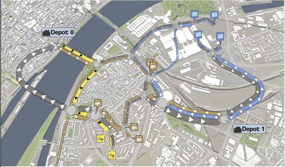
Flow maps are widely used to provide an overview of geospatial transportation data. Existing solutions lack the support for the interactive exploration of multiple flow components at once. Flow components are given by different materials being transported, different flow directions, or by the need for comparing alternative scenarios. In this paper, we combine flows as individual ribbons in one composite flow map. The presented approach can handle an arbitrary number of sources and sinks. To avoid visual clutter, we simplify our flow maps based on a force-driven algorithm, accounting for restrictions with respect to application semantics. The goal is to preserve important characteristics of the geospatial context. This feature also enables us to highlight relevant spatial information on top of the flow map such as traffic conditions or accessibility. The flow map is computed on the basis of flows between zones. We describe a method for auto-deriving zones from geospatial data according to application requirements. We demonstrate the method in real-world applications, including transportation logistics, evacuation procedures, and water simulation. Our results are evaluated with experts from corresponding fields.Additional Files and Images

Weblinks
No further information available.BibTeX
@article{Cornel2016CFM,
  title =      "Composite Flow Maps",
  author =     "Daniel Cornel and Artem Konev and Berhard Sadransky and
               Zsolt Horvath and Andrea Brambilla and Ivan Viola and
               J\"{u}rgen Waser",
  year =       "2016",
  abstract =   "Flow maps are widely used to provide an overview of
               geospatial transportation data. Existing solutions lack the
               support for the interactive exploration of multiple flow
               components at once. Flow components are given by different
               materials being transported, different flow directions, or
               by the need for comparing alternative scenarios. In this
               paper, we combine flows as individual ribbons in one
               composite flow map. The presented approach can handle an
               arbitrary number of sources and sinks. To avoid visual
               clutter, we simplify our flow maps based on a force-driven
               algorithm, accounting for restrictions with respect to
               application semantics. The goal is to preserve important
               characteristics of the geospatial context. This feature also
               enables us to highlight relevant spatial information on top
               of the flow map such as traffic conditions or accessibility.
               The flow map is computed on the basis of flows between
               zones. We describe a method for auto-deriving zones from
               geospatial data according to application requirements. We
               demonstrate the method in real-world applications, including
               transportation logistics, evacuation procedures, and water
               simulation. Our results are evaluated with experts from
               corresponding fields.",
  journal =    "Computer Graphics Forum",
  volume =     "35",
  number =     "3",
  pages =      "461--470",
  URL =        "https://www.cg.tuwien.ac.at/research/publications/2016/Cornel2016CFM/",
}